Fundy National Park Guide: Bay of Fundy Tides & Hiking
There’s a place on Canada’s eastern edge where the ocean rises and falls like nowhere else on Earth. Every 12 hours and 25 minutes, the Bay of Fundy empties and refills with enough water to cover the planet in a few centimeters.
Highest tides in the world: up to 16 meters (52 feet) · Park area: 206 km² (80 sq mi) · Year established: 1946 · Hiking trails: 120 km (75 mi) · Nearest village: Alma, New Brunswick · Camping sites: over 600
Quick snapshot
- World’s highest tides occur in the Bay of Fundy (Parks Canada).
- Over 120 km of hiking trails traverse the park (Intrepid Escape).
- No entry fee as of 2025 (Parks Canada fee page).
- Exact annual visitor numbers – ~1 million is a rough estimate.
- Future fee changes have not been announced.
- Tide height range varies by lunar phase and location along the coast.
- 1946 – Fundy National Park established.
- 2010 – Designated a UNESCO Biosphere Reserve.
- Plan around tide schedules for the best coastal experience.
- Book camping early – sites fill fast in summer.
The table below compiles the essential stats you need before planning a trip.
| Location | Near Alma, New Brunswick, Canada |
| Size | 206 km² (80 sq mi) |
| Established | April 10, 1946 |
| Tidal range | Up to 16 m (52 ft) |
| Annual visitors | ~1 million |
| Hiking trails | 120 km (75 mi) |
What is special about Fundy National Park?
Unique tidal phenomena
- The Bay of Fundy’s tides are the highest on Earth, rising up to 16 meters (52 feet) in extreme conditions (Parks Canada, the federal agency managing national parks).
- The tidal flow reverses direction twice daily, churning more water than all the rivers of the world combined.
- At low tide, the ocean floor is exposed for kilometers, revealing rocks, mudflats, and tidepools.
The implication: The same shoreline transforms from a submerged seascape to a walkable plain in six hours – a spectacle you can’t see anywhere else at this scale.
Acadian forest ecosystem
- The park protects a rare remnant of Acadian Forest, a mix of hardwood and softwood that once covered the region (Intrepid Escape, a travel site covering Atlantic Canada).
- More than 25 waterfalls are scattered through the forest, many visible from maintained trails (Hike Bike Travel, a hiking-focused blog).
- The Caribou Plain Boardwalk (0.5 km) lets you cross a wetland without getting wet.
The pattern: A protected ecosystem this intact, paired with easy access, is rare in a national park this close to major cities.
Wildlife and biodiversity
- Black bears, moose, white-tailed deer, and over 260 bird species call the park home (Hike Bike Travel).
- Bald eagles and peregrine falcons nest along the coastal cliffs.
- Intertidal zones teem with crabs, starfish, and anemones that reappear with every low tide.
Why this matters: For a park that sees roughly 1 million visitors a year, the wildlife sightings remain consistent – that reflects the park’s zoning and interpretive programs.
Where is the best spot to see the Bay of Fundy?
Top viewpoints like Hopewell Rocks
- Hopewell Rocks, about 40 minutes south of the park, is the most famous spot to see flowerpot rock formations and the tide change (Trip of a Lifestyle, a Canada travel resource).
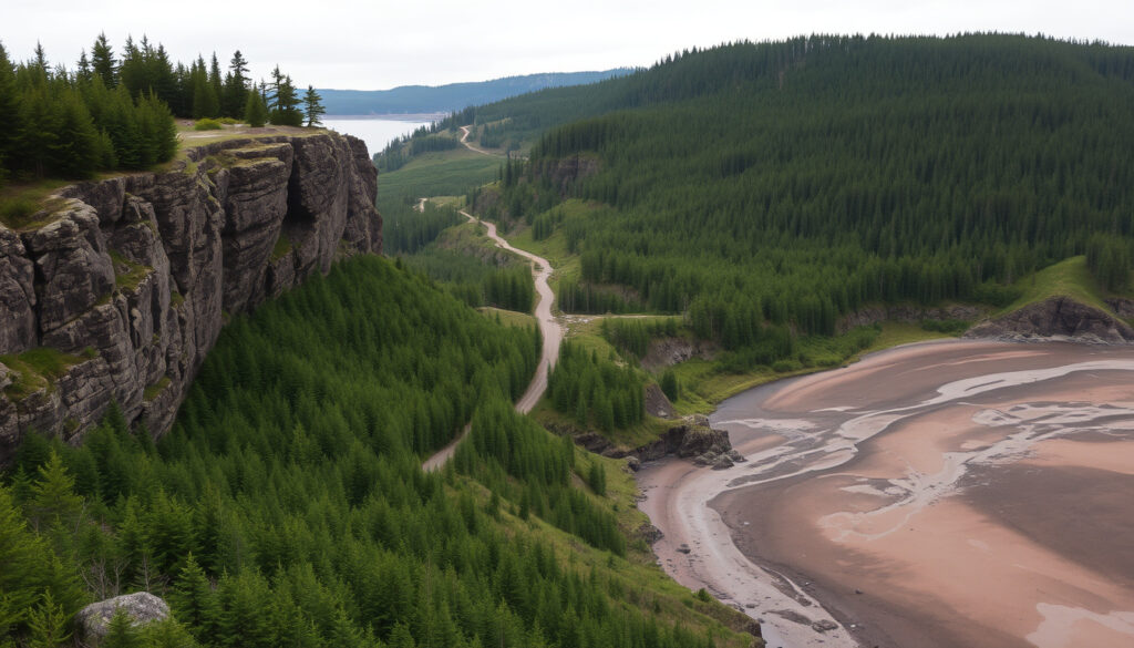
- Inside Fundy National Park, the Coastal Trail (13.8 km) offers multiple viewpoints.
- Herring Cove Beach is also accessible by car and ideal for picnics during low tide (Hike Bike Travel).
The trade-off: Hopewell Rocks draws crowds, but the park’s own viewpoints are quieter and just as dramatic when you time the tides right.
Best times of day to see tides
- High tide: you can kayak up to the base of the cliffs.
- Low tide: you can walk the ocean floor and explore tidepools.
- Both phases occur roughly 50 minutes later each day – check the official tide schedule before heading out.
What to watch: The hour before and after low tide is the sweet spot for photography and walking the exposed seabed.
Access by car from nearest city
- From Moncton (45 min drive): take Route 114 south to Alma.
- From Saint John (1.5 h drive): follow Route 1 to Route 114.
- The park entrance is just past the village of Alma, New Brunswick.
The catch: Without a car you lose flexibility — tide windows don’t wait for bus schedules, and ride-share options are limited outside Moncton.
Is the Bay of Fundy worth visiting?
Reasons to visit
- You’ll witness a natural phenomenon that makes you feel the planet’s pulse.
- The park offers 120 km of trails, waterfalls, boardwalks, and coastal views (Intrepid Escape).
- Entry is free (no fee as of 2025).
- Alma’s restaurants serve fresh lobster and clams within walking distance of the park.
The upshot: Few places combine a world-class natural wonder with accessible hiking and affordable camping. The value proposition is strong.
Potential drawbacks
- Weather in spring and fall can be rainy and chilly.
- Peak summer brings long lines at the park entrance and crowded campgrounds.
- Some trails are steep and muddy after rain.
- Cell service is spotty or absent inside the park.
The catch: If you come between July and August without a camping reservation, you may not find a site – and fog can obscure the views.
Overall verdict
- For nature lovers, photographers, and families who don’t mind a little dampness: absolutely worth it.
- For luxury travelers seeking hotel comforts: plan a base in Alma or Saint John and day-trip into the park.
What is the best time to visit the Bay of Fundy?
Seasonal highlights
- Summer (June–August): warmest weather, all trails open, swimming at Bennett Lake and Wolfe Lake (Hike Bike Travel).
- Spring (May–June): fewer crowds, waterfalls at peak flow, cooler temperatures.
- Fall (September–October): foliage colors, lower humidity, fewer bugs.
- Winter (November–April): park services limited, but cross-country skiing and snowshoeing are possible.
Optimal months for tide viewing
- The highest tides occur in spring and fall when the moon is closest to Earth.
- Check the Bay of Fundy tide schedule for the 2–3 days with the greatest tidal range.
- Sunrise and sunset low tides are especially photogenic.
Weather considerations
- July and August averages: 20–22°C (68–72°F).
- Fog is common in June and July, especially near the coast.
- Rainfall is spread evenly year-round; pack waterproof gear regardless of season.
The implication: The best time for a first-time visitor is mid-July to early September, when the weather is most reliable and all park amenities are operating.
What are the best things to do at Fundy National Park?
Hiking trails
- Dickson Falls: 1.5 km loop, easy, leads to a 25-foot (7.6 m) waterfall (Hike Bike Travel).
- Coastal Trail: 13.8 km, moderate, with ocean cliffs and sea stacks (Hike Bike Travel).
- Matthews Head Trail: 3.2 km, moderate, views of Alma and the coast.
- Fundy Circuit: 48 km multi-day hike (3–5 days) linking seven trails (Hike Bike Travel).
- Goose River Trail: moderate, scenic river and coastline views (Chasing ADVNTR, an adventure travel blog).
- Caribou Plain Boardwalk: 0.5 km wheelchair-accessible wetland walk.
Camping
- Three campgrounds: Headquarters (RV and tent), Wolfe Lake (walk-in tent only), and Bennett Lake (RV and tent with beach access).
- Over 600 campsites total; reservations required through Parks Canada (Intrepid Escape).
- Camping rates (2025): ~$30–45 per night depending on site type.
Interpretive programs
- Parks Canada runs guided tidepool walks, stargazing sessions, and Acadian forest talks.
- Junior ranger program for kids (ages 6–12) with activity booklets.
- Check the daily program board at the visitor center.
Water activities
- Kayaking in the Bay of Fundy: Fresh Air Adventure in Alma offers guided tours (Hike Bike Travel).
- Swimming at Bennett Lake or Wolfe Lake (lifeguards on duty in peak season).
- Fishing: license required; brook trout are common in park streams.
The pattern: The park is designed for self-guided exploration, but the interpretive programs add depth – especially for families who want a structured learning experience alongside their adventure.
How do I plan a visit to Fundy National Park?
Getting there
- By car: 45 minutes south of Moncton via Route 114. Nearest major airport: Greater Moncton Roméo LeBlanc International Airport (YQM).
- By taxi or rideshare: available from Moncton (about CAD 60–80 one way).
- Parking is free inside the park.
Accommodation options
- Camping (tent or RV) inside the park – book via Parks Canada reservation system at least 2 weeks in advance for summer.
- Alma village: inns, B&Bs, and motels – book ahead from June to August.
- Saint John or Moncton: full-service hotels for a city base with day trips into the park.
Park passes and fees
- No entry fee (as of 2025).
- Camping fees apply; firewood permits are extra.
- Fishing license: buy online or at the visitor center.
Packing list
- Rain jacket and quick-dry pants (even in summer).
- Sturdy hiking boots with ankle support.
- Binoculars and camera with zoom lens.
- Insect repellent with DEET (black flies are active in June).
- Tide schedule printout or app.
- Snacks and water – food services are limited inside the park.
What this means: A well-packed day bag is the difference between a soggy frustration and a memorable adventure. The park’s isolation (limited cell service, few stores) demands self-sufficiency.
You can see the entire park in a single day if you drive the Fundy Parkway (20 km) and stop at three viewpoints. But the hiking trails deserve at least two nights – one for the coast, one for the waterfalls. Campers who stay three nights report the most satisfaction, because they match the tidal cycle, not the clock.
First‑time visitors who skip the tide schedule often leave disappointed because they arrived at high tide and saw nothing but water. A simple 5‑minute check of the daily tidal range tells you exactly when the ocean floor will be exposed. Parks Canada publishes the schedule on its website and at the visitor center.
Pros and cons
Upsides
- World‑record natural phenomenon right on the park’s doorstep.
- Free entry.
- Over 120 km of trails for all fitness levels.
- Three campgrounds with a range of styles (RV, tent, walk‑in).
- Alma’s seafood restaurants add a culinary bonus.
- Quiet enough in spring/fall for solitude.
Downsides
- Peak‑summer crowds can make trails feel full.
- Unpredictable weather – fog, rain, and mud are common.
- Cell service is unreliable; no Wi‑Fi in most areas.
- Food services inside the park are basic and limited.
- Some trails are steep and require good fitness.
- Camping reservations fill weeks in advance during July and August.
Steps to plan your trip
- Choose your travel dates – aim for mid‑July to early September for best weather.
- Check the tide schedule for your dates – note the low‑tide window each day.
- Book camping or accommodation in Alma/Moncton at least two weeks ahead for summer.
- Download a park map (PDF) from the Parks Canada website.
- Pack waterproof layers, sturdy shoes, insect repellent, and snacks.
- Drive into the park via Route 114; stop at the Visitor Center for current trail conditions.
- Plan your first hike around low tide – start with the Coastal Trail for ocean views, then Dickson Falls in the afternoon.
- Leave no trace – pack out all garbage and respect wildlife distances.
The catch: The single biggest mistake is arriving without a tide plan. You can’t see the tidepools if the water is still high, and you can’t kayak through narrow channels if the water is ebbing. Align your daily schedule with the tide clock, not the lunch clock.
Clarity check: what we know and what’s uncertain
Confirmed facts
- Highest tides in the world occur in the Bay of Fundy (Parks Canada).
- Fundy National Park was established in 1946 (Government of Canada).
- The park has over 120 km of hiking trails (Intrepid Escape).
- Dickson Falls is a 1.5‑km loop trail with a 25‑ft waterfall (Hike Bike Travel).
- Camping is available in three campgrounds with over 600 sites.
- Entry is free as of 2025.
What’s unclear
- Exact annual visitor numbers – ~1 million is a rough estimate.
- Future fee changes have not been announced.
- Some sources claim tides reach 38 feet, others say 52 feet – the official range depends on lunar phase and location.
Quotes from visitors and experts
“The biggest surprise was how fast the water returns. We were walking on the ocean floor one minute, and within 45 minutes the water was lapping at our boots. It’s like nature’s elevator.”
“Kayak right up to the rock formations at high tide and you’re eye‑level with the flowerpots. That’s when you realize how powerful the water really is.”
“Parks Canada runs an excellent tidepool program for families. Our kids learned more about intertidal life in one hour than in a year of science class.”
The Bay of Fundy’s tides are not a show you watch from a distance – they are a force you step into, walk on, and paddle through. Fundy National Park gives you the access, the trails, and the campsites. The only question left is when you’ll go. For the casual visitor, the choice is clear: book a mid‑July camping spot now, bring a rain jacket, and plan your day around the tide schedule. For the serious hiker, tack on the Fundy Circuit for three days of solitude that few parks this close to a city can still deliver.
Frequently asked questions
Can I bring pets to Fundy National Park?
Yes, pets are allowed on most trails but must be leashed at all times. They are not permitted on swimming beaches (Bennett Lake, Wolfe Lake) or inside park buildings.
What is the entrance fee for Fundy National Park?
As of 2025, there is no entry fee. Camping and firewood permits still require payment.
Are there guided tours available?
Parks Canada offers interpretive programs (tidepool walks, stargazing) daily in summer. Private companies like Fresh Air Adventure in Alma run kayak tours.
What is the nearest airport to Fundy National Park?
Greater Moncton Roméo LeBlanc International Airport (YQM) is about 45 minutes north by car.
Is there cell service in the park?
Cell service is unreliable – most trails and campgrounds have no signal. Wi‑Fi is available only at the visitor center.
Can I kayak in the Bay of Fundy?
Yes. Guided tours are recommended because the tidal currents are strong. Fresh Air Adventure in Alma offers rentals and guided trips.
Are there any food services in the park?
There is a small café at the visitor center (seasonal) and a convenience store near Headquarters Campground. Alma has full‑service restaurants and a grocery store.
More related posts
 Quelle Heure Est-Il En France – CET/CEST Time Guide for Paris
 RBC Customer Service Number: 1-800-769-2511 | 24/7 Hours
 Maine Coon Cat Size: How Big Do They Get? [Full Growth Guide]
 Julianne Hough Movies and TV Shows – Complete Filmography Guide
 36.8 Celsius to Fahrenheit: Fever Threshold and Normal Range
 How to Get Rid of a Sinus Infection in 24 Hours: Home Remedies
 Games Like Wasteland 3 – Top Turn-Based RPG Alternatives
 The Long Walk Reviews: RT, Critics & Reddit Reactions
